Mapping the global threat of land subsidence
Gerardo Herrera-García, Pablo Ezquerro, Roberto Tomás, Marta Béjar-Pizarro, Juan López-Vinielles, Mauro Rossi, Rosa M. Mateos, Dora Carreón-Freyre, John Lambert, Pietro Teatini, Enrique Cabral-Cano, Gilles Erkens, Devin Galloway, Wei-Chia Hung, Najeebullah Kakar, Michelle Sneed, Luigi Tosi, Hanmei Wang, Shujun Ye
Summary
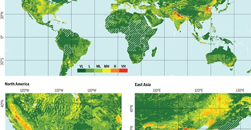
Subsidence, the lowering of Earth's land surface, is a potentially destructive hazard that can be caused by a wide range of natural or anthropogenic triggers but mainly results from solid or fluid mobilization underground. Subsidence due to groundwater depletion (1) is a slow and gradual process that develops on large time scales (months to years), producing progressive loss of land elevation (centimeters to decimeters per year) typically over very large areas (tens to thousands of square kilometers) and variably affects urban and agricultural areas worldwide. Subsidence permanently reduces aquifer-system storage capacity, causes earth fissures, damages buildings and civil infrastructure, and increases flood susceptibility and risk. During the next decades, global population and economic growth will continue to increase groundwater demand and accompanying groundwater depletion (2) and, when exacerbated by droughts (3), will probably increase land subsidence occurrence and related damages or impacts. To raise awareness and inform decision-making, we evaluate potential global subsidence due to groundwater depletion, a key first step toward formulating effective land-subsidence policies that are lacking in most countries worldwide.
Science 01 Jan 2021: Vol. 371, Issue 6524, pp. 34-36, DOI: 10.1126/science.abb8549
This is an article distributed under the terms of the Science Journals Default License.
More Publications
-
 Analysing the Impact of Land Subsidence on the Flooding Risk: Evaluation Through InSAR and Modelling
A new paper entitled "Analysing the Impact of...
-

-

-
 A new Poster was presented in the Living Planet Symposium 2022
The RESERVOIR Project delegation (Gua...
-

RESERVOIR is part of the PRIMA Programme supported by the European Union. The PRIMA programme is supported under Horizon 2020 the European Union's Framework Programme for Research and Innovation. Grant Agreement number: [1924] [RESERVOIR] [Call 2019 Section 1 Water RIA]
#PRIMAProjects #Research #Innovation
@PRIMAInnovation @EuScienceInnov @EU_H2020

Copyright © RESERVOIR 2026. All rights reserved.