THE GEDIZ RIVER BASIN ALLUVIAL AQUIFER (TURKEY)
Geographical Setting
The Gediz River Basin (GRB) is one of the largest watersheds out of 25 major watersheds in Turkey and it is also known as one of the most water-stressed river basins in Turkey. It is located in the Aegean region of Western Turkey between 26° 42' - 29° 45' eastern longitude and 38° 04' - 39° 13' northern latitude coordinates. The GRB has a drainage area of 17034 km2 and it covers about 2.2% of Turkey’s total land area. The GRB is named after its main river reach, the Gediz River, which has a length of about 400 km. The river originates from various major springs that are located in Mount Murat in the northeast of the basin and Mount Bozdağ at an elevation of about 2000 m. Snowpack occurrence and snowmelt processes can only be observed in the upstream parts. The river flows through various morphological settings and fertile agricultural lands, eventually discharging to the Aegean Sea. The basin exhibits a typical Mediterranean climate with hot, dry summers and cool, rainy winters. The long-term mean annual temperature is 15.0 °C and basin-averaged total precipitation is 524 mm, respectively (SYGM, 2017). Total annual precipitation ranges from 420 mm to 672 mm depending on the location in the basin. Most precipitation is typically observed in January and February, whereas July and August are the driest months. The basin-averaged relative humidity is measured as 64 %. A topographical map of the GRB is shown in Fig. 1.
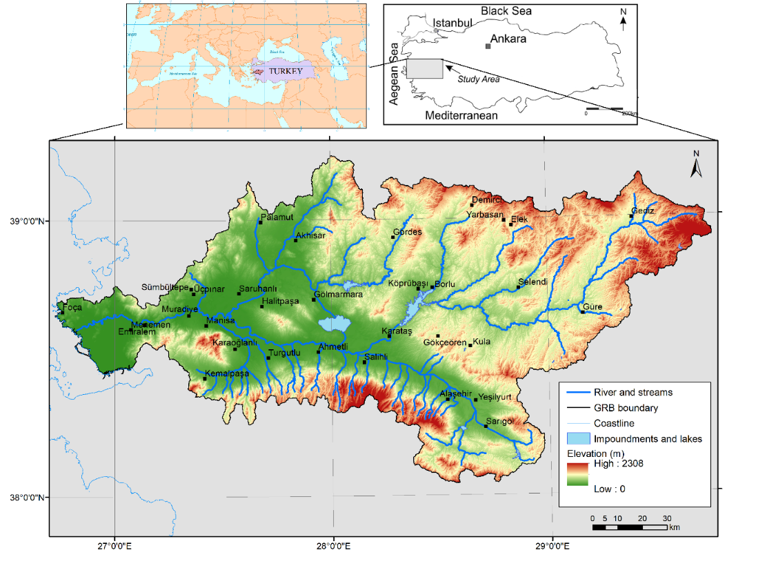 Figure 1. Geographical location of the Gediz River Basin
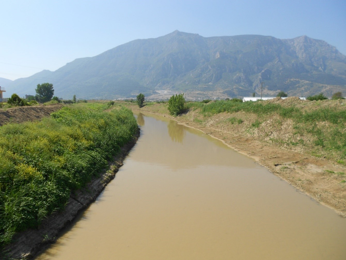
Figure 2. A view of Mount Nif and Nif Stream, one of the tributaries of the Gediz River (photo by Alper Elçi, 2015)
Land Use and Economic Activities
As of 2016, 1.34 million people live in towns and cities; 483 thousand people live in rural areas within the boundaries of the GRB. The main economical activities are agriculture, animal husbandry, food industry, textile industry, geothermal energy production, and mining. All of these activities contribute to environmental problems, combined with natural factors to exert pressures on both quantity and quality of groundwater resources in the basin.
The land use distribution based on the CORINE-2018 database is shown in Fig. 3. The breakdown of land use classes for the entire basin is as follows: Agricultural areas 52% (894,546 ha); artificial surfaces 2% (34,093 ha); forests and semi-natural areas 45% (761,972 ha); wetlands 0.3% (381 ha) and water bodies 0.8% (12,965 ha). Within the boundaries of the alluvial aquifer, the land is predominantly used for agricultural purposes.
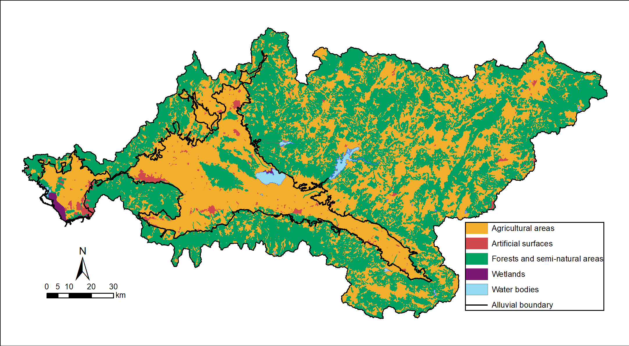
Figure 3. Land use map of the GRB and the boundaries of the alluvial aquifer.
Hydrogeological Setting
Hydrogeology of the GRB is classified as 76 groundwater bodies consisting of different lithological units which are mainly sedimentary units such as clay, sand, and gravel; karstic rocks such as limestones and marbles; fractured volcanic rocks and other types of rocks such as sandstone, shale, schist, and gneiss. Sedimentary units with extensive and abundant groundwater are mainly formed by alluvial deposits. These units are referred to as the alluvial aquifer of the GRB or the Gediz Plain Aquifer, which is developed mostly in the WNW-ESE directional Gediz graben area. The GRB alluvial aquifer constitutes a significant share of the total groundwater potential in the basin.
The dominant mechanism of groundwater recharge in the GRB alluvial aquifer is percolation of precipitation water. Mountain-front recharge and irrigation return flow are secondary mechanisms of recharge. The spatial distribution of recharge is heterogeneous with higher rates observed in the plain. The mean annual groundwater recharge is estimated at 165 mm.
Specific capacities of groundwater pumping wells are important indicators of the groundwater productivity of a groundwater body. Based on an analysis of data in the year 2014 obtained from 994 well logs, the spatial distribution of specific capacity was obtained for the alluvial aquifer. Specific capacity values range from 0.01 to 45.8 L/s per m of drawdown. Higher values can be observed at alluvial fans around the branches of the Gediz River.
Hydraulic conductivities (K) display a wide range of values depending on whether the well is drilled in Neogene sedimentary rocks (flysch, sandstone, and claystone), alluvial sediments (gravel, sand, and silt) or karstic formations (limestones). The observed range of K values for selected wells is reported as 0.05 to 8 m/d.
Based on a groundwater flow modeling study (Elçi et al, 2015) groundwater head values in the alluvial aquifer range from -50 m to 568 m. The distribution of heads for the alluvial aquifer is shown in Fig. 4 as a line contour map. The modeling study showed that head gradients are very steep at the perimeter of the alluvial aquifer resulting in large groundwater fluxes toward the alluvial plains in the GRB. The dominant groundwater flow direction is roughly towards the west. Furthermore, lateral recharge from mountain foothills appears to have a significant role in the groundwater dynamics of the basin.
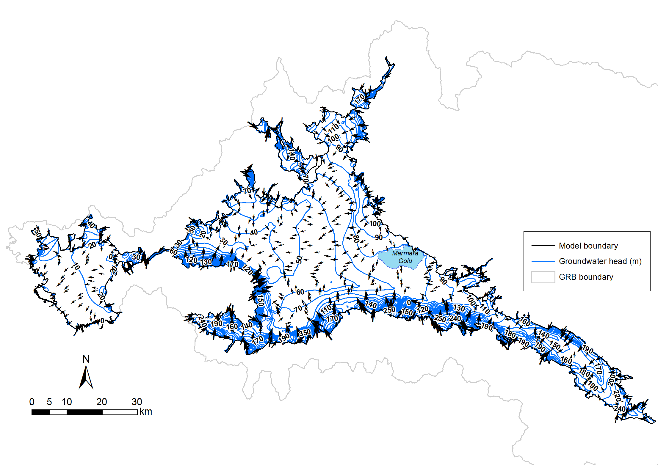
Figure 4. Groundwater heads and flow directions (arrow sizes are proportional to flow velocities) in the GRB alluvial aquifer calculated using a MODFLOW-driven groundwater flow model (Elçi et al., 2015).
Groundwater Usage
Drinking water in the GRB is mostly supplied by groundwater wells. At the sub-basin level, the ratio of groundwater sources for drinking water usage varies between 80% and 97%. As of the year 2016, the total demand for drinking water in the GRB is calculated as 152.3 million m3 per year of which over 80% is supplied from various confined and water table aquifers.
If only the alluvial aquifer is considered, it is estimated that a total of 133.5 million m3 of groundwater is pumped per year from the alluvial aquifer (Agartan and Yazicigil, 2012). Approximately 84% of the total groundwater consumption is for agricultural irrigation, 16% of the groundwater is used for drinking, domestic and industrial purposes.
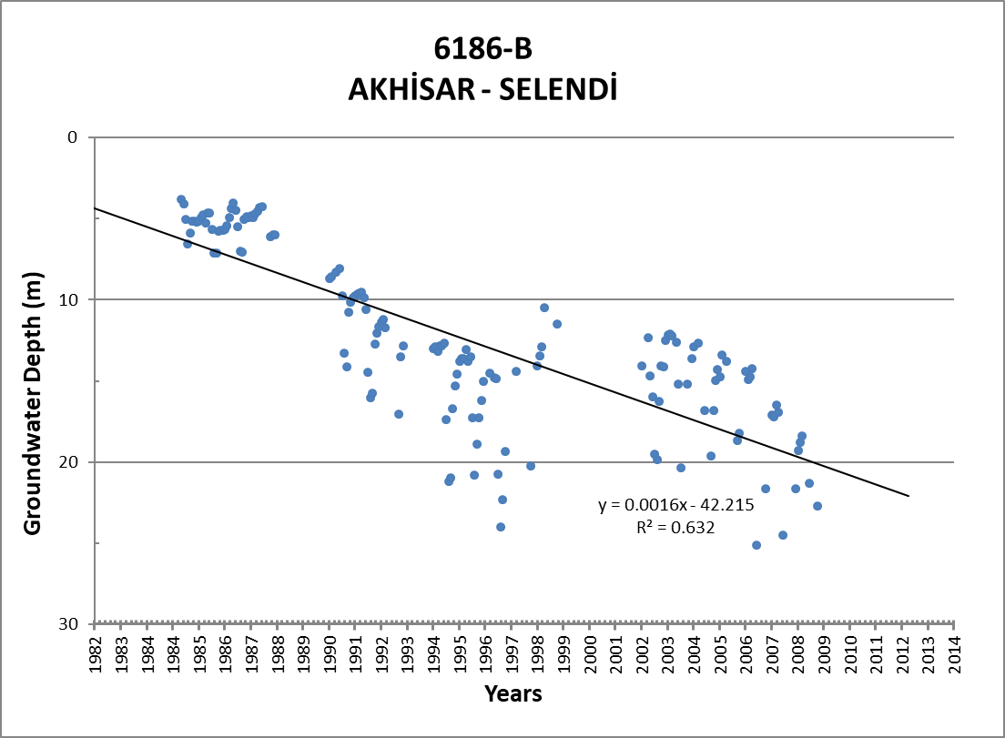
Over-abstraction of groundwater from thousands of pumping wells caused steady declines of groundwater reserves in the GRB. An analysis of measurements from wells with long time series of monitoring data reveals that there is a decreasing trend in piezometric heads for the vast majority of wells. The average rate of the decrease in head varies between 9.9 and 152.2 cm per year. Fig. 5 illustrates the decreasing trends in the piezometric head at two selected monitoring well in the GRB alluvial aquifer.
 |
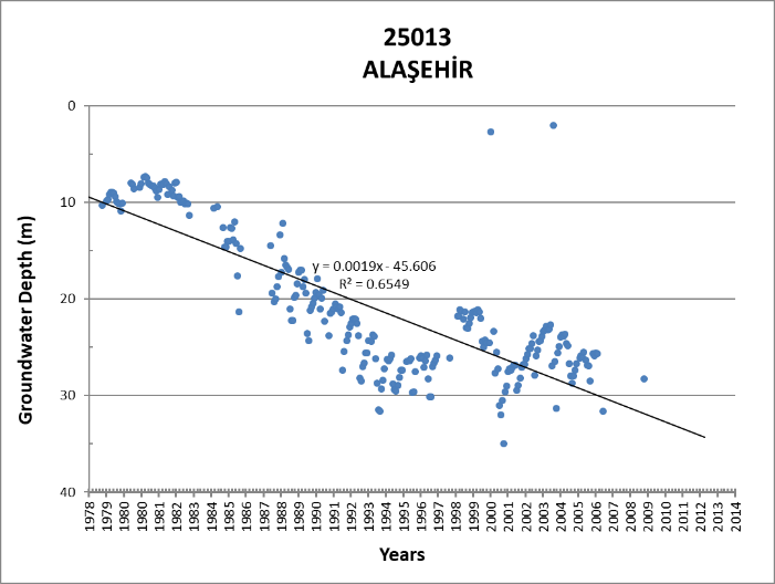 |
Figure 5. Temporal change in piezometric heads in two selected wells located in the GRB alluvial aquifer.
References
Agartan, E., & Yazicigil, H. (2012). Assessment of Water Supply Impacts for a Mine Site in Western Turkey. Mine Water and the Environment, 31(2), 112–128.
Elçi, A., Şimşek, C., Gündüz, O., Baba, A., Acinan, S., Yıldızer, N., & Murathan, A. (2015). Simulation of Groundwater Flow in the Gediz River Basin. EWRA 9th World Congress, 1–12. https://doi.org/10.13140/RG.2.1.4694.6404
RESERVOIR is part of the PRIMA Programme supported by the European Union. The PRIMA programme is supported under Horizon 2020 the European Union's Framework Programme for Research and Innovation. Grant Agreement number: [1924] [RESERVOIR] [Call 2019 Section 1 Water RIA]
#PRIMAProjects #Research #Innovation
@PRIMAInnovation @EuScienceInnov @EU_H2020


Copyright © RESERVOIR 2026. All rights reserved.