The main aim of RESERVOIR is to provide new products and services for a sustainable groundwater management model to be developed and tested in four water-stressed Mediterranean pilot sites and then be applicable in other regions via an interdisciplinary approach.
Also, RESERVOIR project aims to improve the hydrogeological characterisation and the numerical groundwater flow modelling process, by integrating derived results from EO data to simulate spatial and temporal evolution of piezometric level and water balance. Land subsidence measurements derived from A-DInSAR data will improve the conceptual and physical groundwater flow model and used calibrate the deformation model.
The specific Project Objectives (PO) are the following:
|
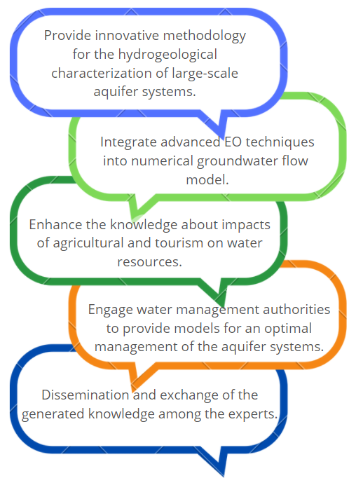
PO1. Develop an innovative methodology for the hydrogeological characterization of large-scale aquifer systems using low-cost and non-intrusive data such as satellite-based Earth Observation (EO) techniques. This methodology will be developed for 4 known water-stressed pilot sites in Mediterranean areas. PO2. Integrate advanced EO techniques into numerical groundwater flow and geomechanical models to improve the knowledge about the current capacity to store water and the future response of aquifer systems to natural and human-induced stresses. PO3. Enhance the knowledge about the impacts of agricultural and tourism activities on the water resources by quantifying the ground deformation during the monitored periods. PO4. Engage water management authorities and provide models for an optimal management of the aquifer systems. The water authorities will be involved in the conceptualization and design of guidelines for Groundwater Resource Management (GRM). PO5. Dissemination and exchange of the generated knowledge among the experts and the managers in charge of land and groundwater management in the pilot sites to strengthen the aquifer resilience. |
 |
RESERVOIR is part of the PRIMA Programme supported by the European Union. The PRIMA programme is supported under Horizon 2020 the European Union's Framework Programme for Research and Innovation. Grant Agreement number: [1924] [RESERVOIR] [Call 2019 Section 1 Water RIA]
#PRIMAProjects #Research #Innovation
@PRIMAInnovation @EuScienceInnov @EU_H2020

Copyright © RESERVOIR 2026. All rights reserved.