THE ALTO GUADALENTÍN AQUIFER
The Alto Guadalentín aquifer is located in Murcia Region, Southeast Spain (Figure 1 and Figure 2). The Segura Hydrographic Demarcation (SHD) is the organism that manages both surface and ground water bodies in the area.
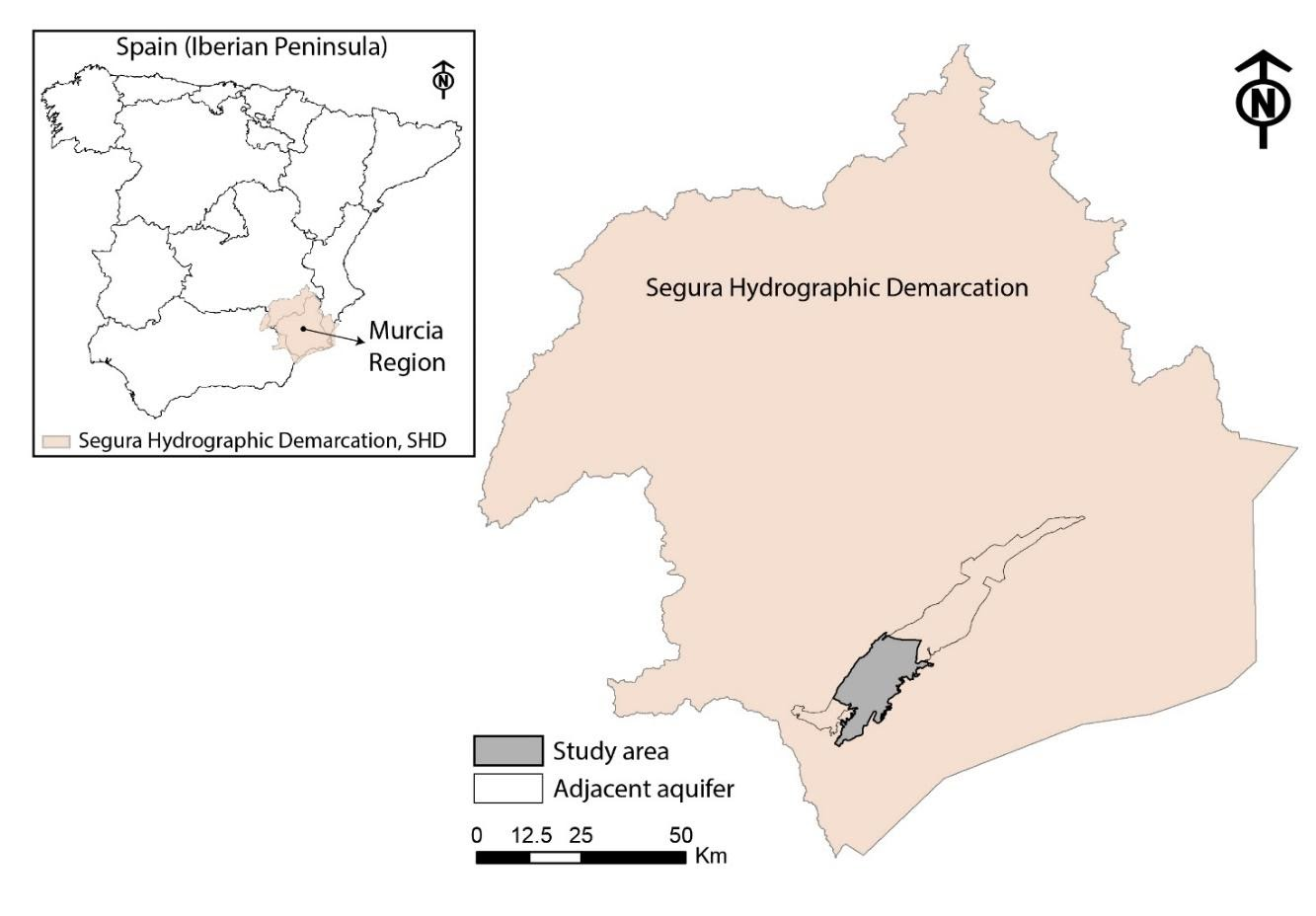 Figure 1: Segura Hydrographic Demarcation.
Within the boundaries of the SHD, the Alto Guadalentín aquifer is placed in a large basin developed by tectonic shifts. The aquifer has an extension of 273 km2 with altitudes varying from 251 m a.s.l. to 551 m a.s.l. (Figure 2). The main watercourse in the area is the Guadalentín River with very low flow non-permanent rates that only increase due to extreme flood events (Ezquerro et al. 2017), reaching up to 3000 m3/s (Cerón 1995). There are other non-permanent watercourses (e.g. Viznaga, Nogalte, Galian), which also become active after these extreme flash floods events (Ezquerro et al. 2020). These water courses do not reach the Guadalentín River since they directly infiltrate to the aquifer or reach endorheic depressed areas (Cerón 1995). Mediterranean areas such as the Southeast of Spain are affected by convective storms (commonly developed in autumn) with very quick development, short duration and very high intensity constituting a permanent potential threat (Jodar-Abellan et al. 2018). Particularly, for Guadalentín basin, these events resulted in numerous catastrophic floods with episodes registered from XIII century until the present (Ezquerro et al. 2017).
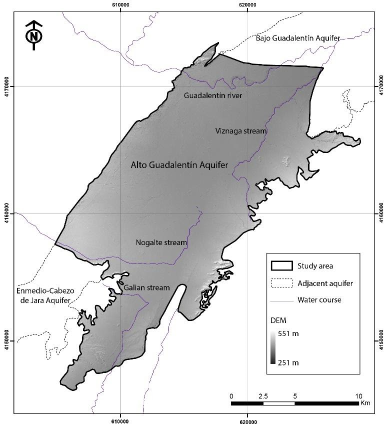 Figure 2: Alto Guadalentín aquifer.
The area presents a dry climate following the Koppen-Geiger Classification modified (AEMET-IM 2011). This matches with severe drought periods and the absence of vegetation in the closer mountains that stablish the aquifer borders. Precipitation presents an average annual value of 283 mm (calculated for the period 1957-2017) and a non-regular temporal behaviour with interannual drought periods and nearly inexistent precipitation during summer. Several drought periods have been declared from 1980 (1980-1983; 1993-1995; 2005-2008; 2015-2018 (Figure 3).
Consequently, water stress in the area has historically appeared with temporal effect causing water shortages. The potential and real evapotranspiration are 993 mm/year y 341 mm/year, respectively. Average values of calculated water infiltration for the study area are very low, not higher than 5 mm/year.
Land uses in the study area comprise artificial (4.5%), agricultural (91.0%) and forest areas (4.5%). Among the agricultural areas (248 km2), 85% corresponds to irrigated surfaces. Related to the artificial land use, Lorca and Puerto Lumbreras constitute the two principal urban areas (Figure 4). The population in the basin area reached 107,000 inhabitants in 2012, with a slow decreasing trend since then (data from annual census, Spanish Statistical Office; Ezquerro et al. 2020). The main population centre is Lorca city (nearly 94,500 inhabitants in 2019), which constitutes the third most populated urban area in the Murcia Region. The economy is based mainly on irrigated agriculture, although farming and industrial activities are also weakly developed (Cerón 1995). Agricultural development has led to the overexploitation of the aquifer system (CHS 2007).
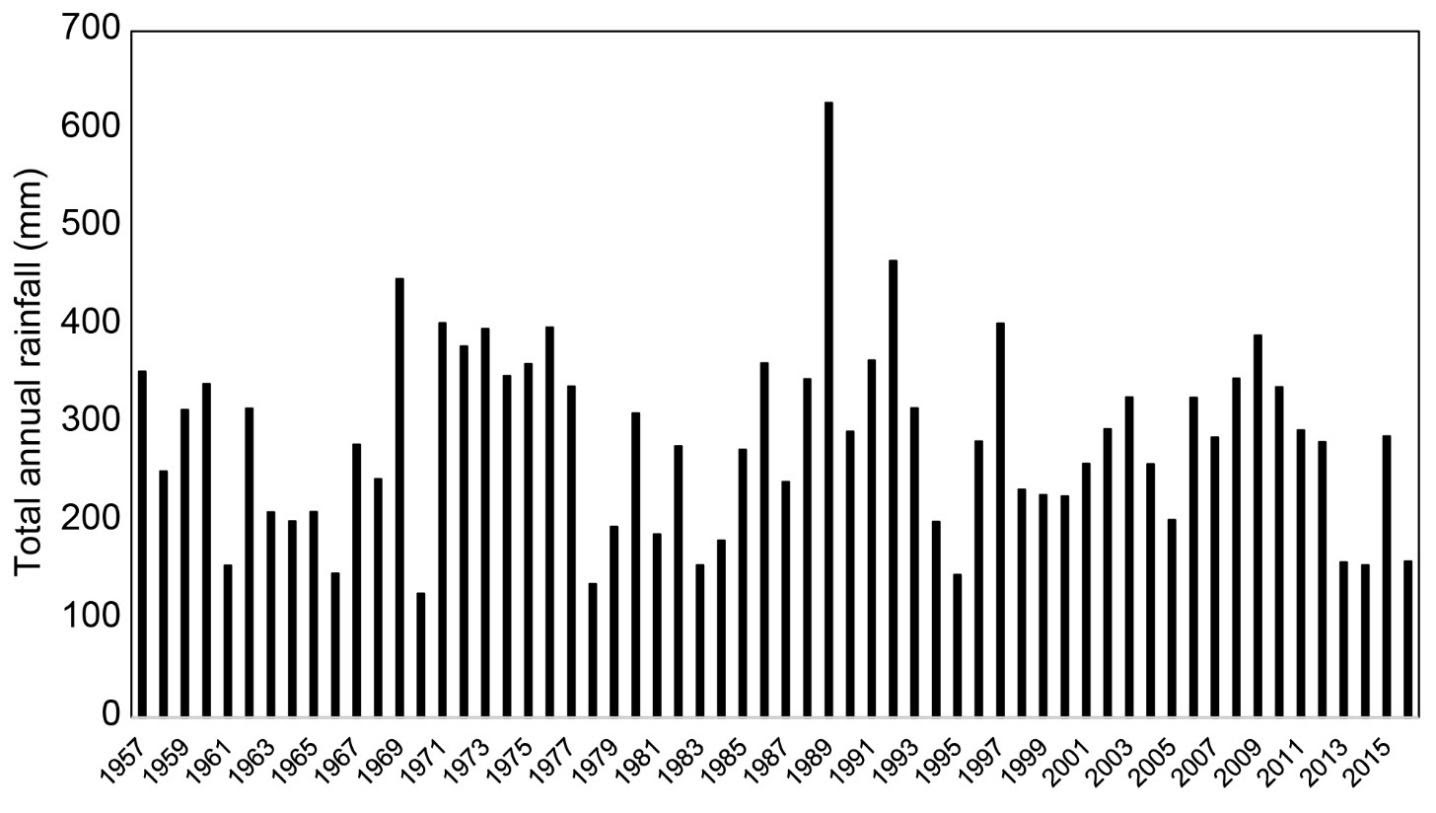 Figure 3 Average annual precipitation in the study area (AEMET).
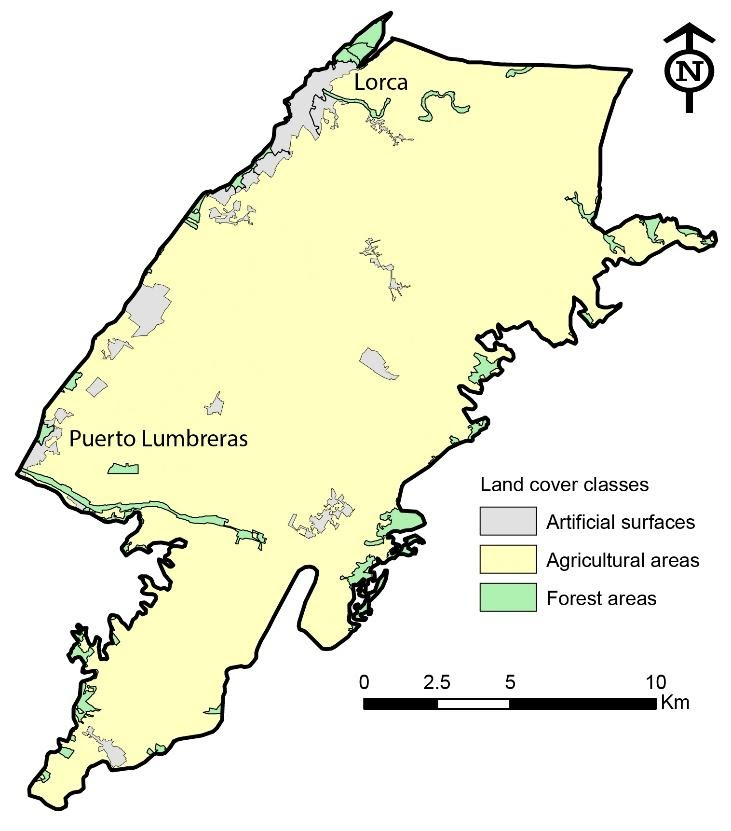 Figure 4 Land uses in the Alto Guadalentín aquifer (Corine Land Cover 2018).
Geological setting
The Guadalentín basin is a tectonic depression located in the eastern part of the Betic Cordillera, an alpine orogenic belt resulting from the collision between the African and Iberian Plates (Béjar-Pizarro et al. 2016; Bonì et al. 2015). The ongoing convergence between both plates is responsible for the existence of large and numerous NE-SW faults that appear defining the borders of the valley. These borders are mostly occupied by outcropping MioceneMiocene materials (conglomerates, marls, sandstones) with pronounced dip. Mainly in the left margin of the basin, many normal faults become clearly identified due to the alignment between the filling materials of the basin and the existing materials of the borders. The Alhama de Murcia fault (NW), is the largest fault in the study area. In addition, the fault system Palomares-Almenara also contributes to define the SE aquifer boundary. These fault systems define regions of instabilityinstability and subsidence (Cerón 1995). The basin is a depression with SW-NE direction whichwhich develops from Enmedio mountain to Vega Media Segura basin, the adjacent basin in the NE boundary.
The overlying P-QPlio-Quaternary layers of the basin filling are alluvial materials composed by sand and gravels embedded in a clayed and sandy matrix (Cerón and Pulido-Bosch 1996; Bonì et al. 2015). These filling materials overlap with MioceneMiocene deposits mainly composed (from bottom to top) of marls with conglomerates and sandstones (Figure 5). The bottom of the basin consists of PermianPermian-Triassic metamorphic materials exhibiting a horst and graben structure (Cerón and Pulido-Bosch 1996). The average thickness of the filling layers reaches more than 300 m. However, as a consequence of the horst and graben pattern of the bedrock this thickness increases locally up to 900 m.
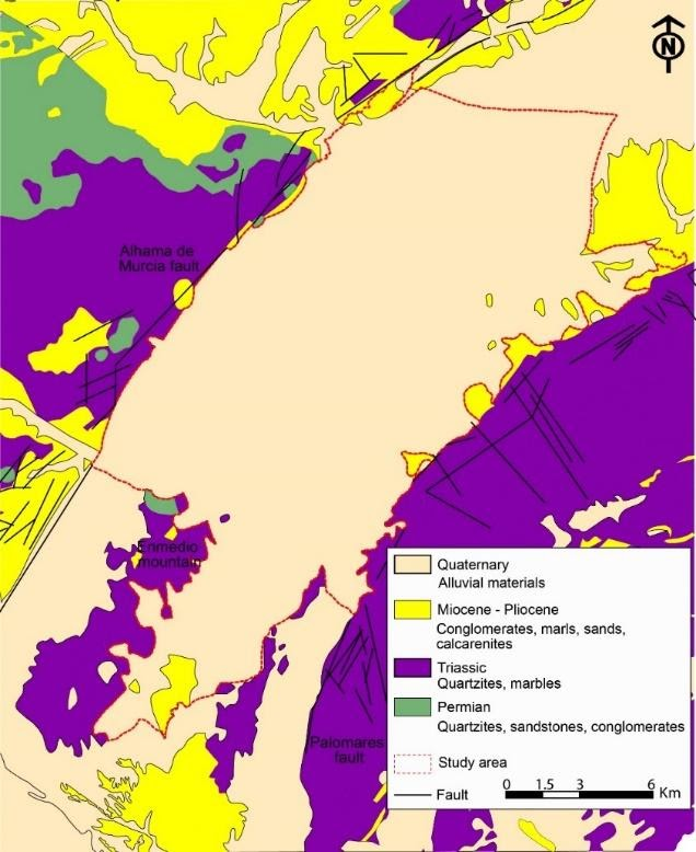 Figure 5 Geological settings of the Alto Guadalentín aquifer (modified from Mapa Geológico de España 1:50000).
Geometry of Plio-Quaternary sediments was studied by Cerón (1995) through vertical electric soundings (VESs) resulting in the Figure 6 a) thickness map. Recent studies developed by Bonì et al. (2015) have demonstrated that Plio-Quaternary materials can be divided into two sublayers. The shallower layer is comprised of soft soils, clays, and silts, while the deeper one is the coarse fraction of Plio-Quaternary materials, sands or gravels, which constitute the main productive layer. Soft soils geometry was estimated by Bonì et al. (2015) using geological information from 23 boreholes in the basin (Figure 6(b)).
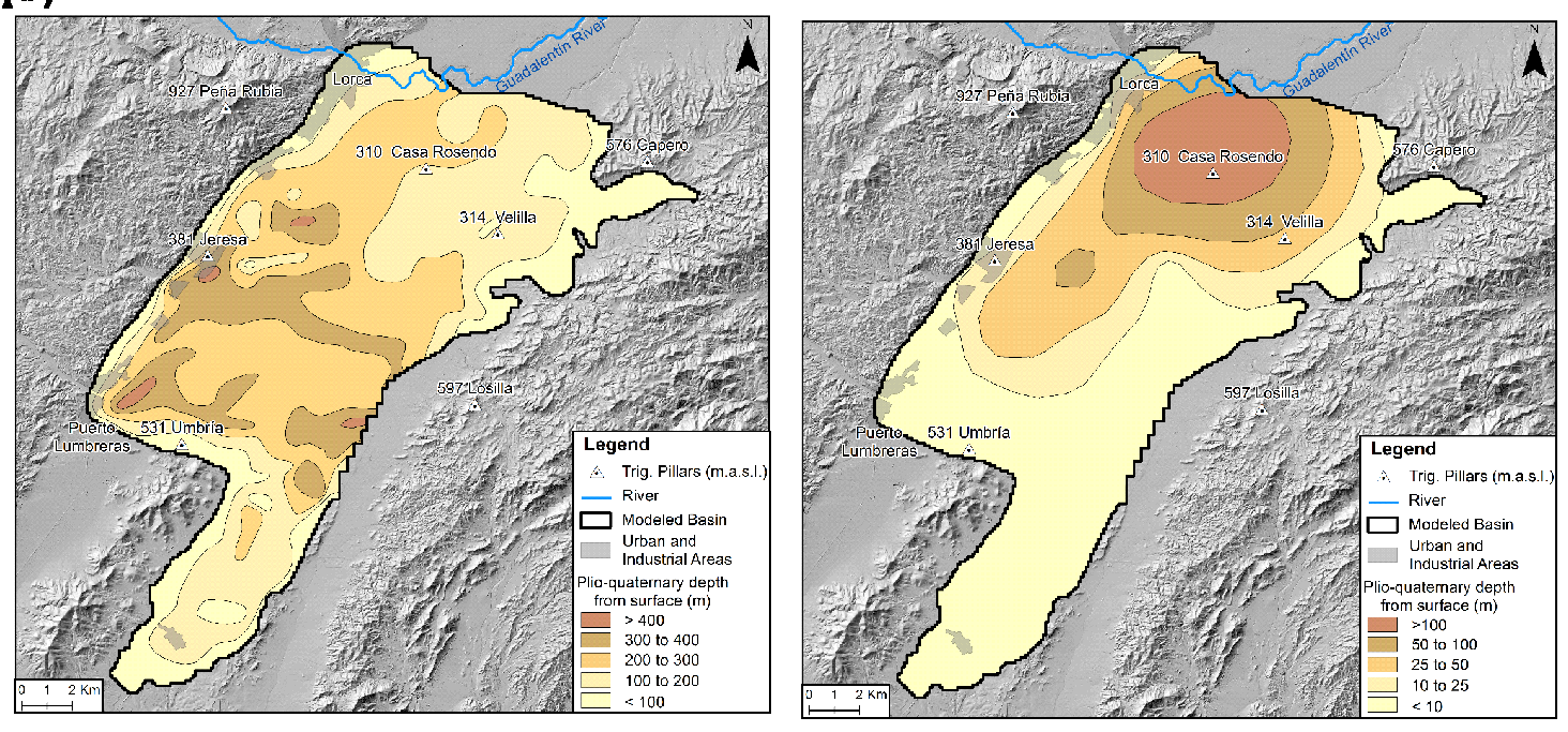 Figure 6 Plio-Quaternary materials depth, derived from Cerón (1995). (b) Compressible soils thickness distribution from Bonì et al. (2015).
The Guadalentín hydrographic system responds to a structural control: the main watercourses fit in the geological fracture system, partially controlled by the faults activity in the Guadalentín area. The hydrographic system provokes multiple deposits and geological features (gullies, badlands, alluvial fans, debris cones, glacis, alluvial terraces, ravines, etc.; Cerón 1995).
Hydrogeological setting
The geometry of the aquifer is defined by limits in NW (Permian-Triassic materials), SE (Triassic-Miocene materials) and N. The northern limit is defined by the contact with the multilayer aquifer system of Bajo Guadalentín. The transition zone between the two aquifers is characterized by thick clay layers that lose lateral continuity towards the Alto Guadalentín. The southern border (open) is defined by the contact with the Sierra de Enmedio triassic loamy materials (CHS 2015). The Plio-Quaternary sediments (gravels and sands) define the upper unconfined aquifer layer followed by a layer composed of Miocene detrital materials with conglomerate and sand deposits. This layer constitutes a low permeable semiconfined level. The Triassic materials represent the deepest impermeable limit.
Aquifer-system recharge strongly depends on rainfall (8.80 hm3/year, CHS 2005). There is an area in the northern part of the basin of 30 km2 with low permeability materials outcropping at the surface which can be considered impervious and not susceptible to surface recharge. There are also inflows to the aquifer system infiltration and stream infiltration through Guadalentín River, Nogalte Rambla and other minor water courses along the eastern and western margins. Another important source of recharge is infiltration from the irrigation return flow (2.70 hm3/year, CHS 2005). Errore. L'origine riferimento non è stata trovata. resumes yearly water inflows estimated for the period 1960-2012 by Ezquerro et al. (2017).
Table 1 Yearly water inflows to the Alto Guadalentín River, estimated for the period 1960-2012 by Ezquerro et al. (2017).
|
Inflows |
Average (hm3) |
Max (hm3) |
Min (hm3) |
|
Guadalentín River |
1.04 |
2.60 |
0.20 |
|
Nogalte Rambla |
1.04 |
2.60 |
0.20 |
|
W rambla |
0.70 |
1.73 |
0.13 |
|
E rambla |
1.39 |
3.47 |
0.27 |
|
Rainfall infiltration |
7.0 |
26.74 |
2.23 |
|
Irrigation returns Lorca Irrigators Association |
2.09 |
2.83 |
1.65 |
|
Irrigation returns Puerto Lumbreras Irrigators Association |
1.55 |
3.09 |
0.12 |
Discharge from the Alto Guadalentín aquifer occurs through the connection with the Bajo Guadalentín aquifer system and the numerous wells pumping its resources. At present, the semiconfined layer is the most productive layer since the upper unconfined layer is mostly depleted. Therefore, the pumping wells that take water from the unconfined layer are, in occasions, nearly 400 m depth. However, in the past, the piezometric level was close to the surface and artesian wells were exploited. The intensive use of groundwater for agricultural purposes since 1960, led to a decline in the aquifer-system levels near 200 m in 50 years (Bonì et al. 2015). Groundwater drawdown became apparent in 1972 (Cerón and Pulido-Bosch 1996). In 1988, the amount of extraction reached maximum historical value of 77.6 hm3/year (Bonì et al. 2015; IGME 1994). After 1988, a general reduction of pumping and/or abandonment of wells were recorded due to CO2 pollution of groundwater resources and to new sources of water transferred from the Tajo River to the Segura River (Cerón and Pulido-Bosch 1996). The evolution of the piezometric levels from 1988 to present shows a continuous decrease trend with an average accumulate value of 30 m (Figure 7). Nowadays, average value of pumping rates is quantified in around 34 hm3/year.
Hydrogeochemistry analyses of the aquifer reveal problems of high concentration of chloride and sulphate in some control points. Moreover, there are isolated areas where nitrates exceed 134 mg/l (CHS 2015).
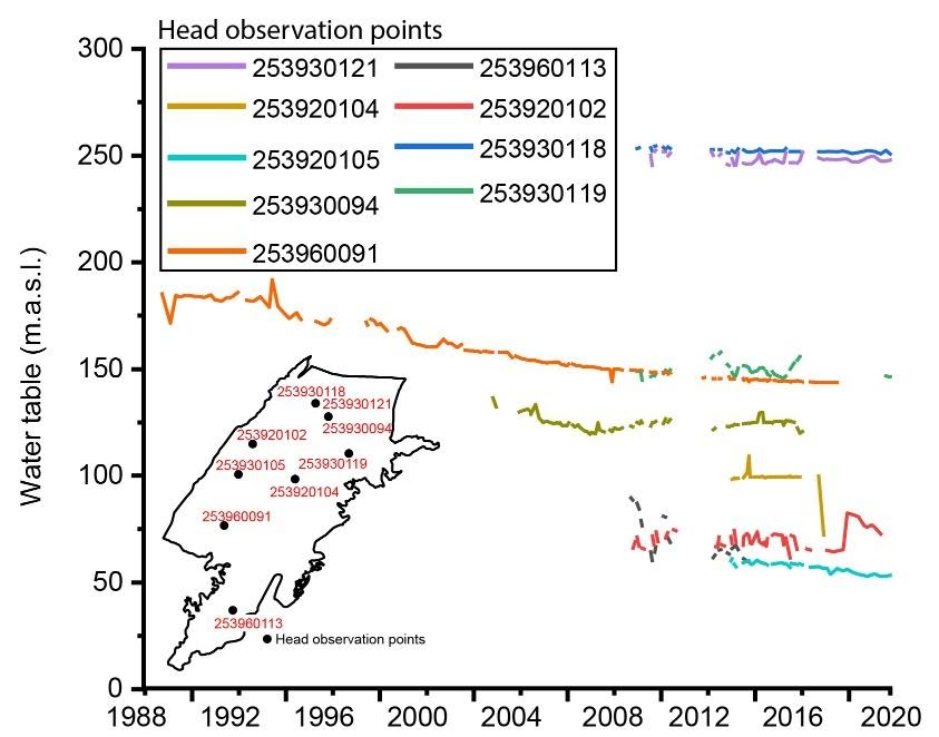
Figure 7 Head observation points and piezometric evolution in the Alto Guadalentín aquifer (CHS 2020, http://www.chsegura.es/chs/cuenca/redesdecontrol/estadisticashidrologicas/visorpiezo/visorjs.html ).
GROUNDWATER POLICIES AND REGULATION
Groundwater use
In the area of the Alto Guadalentín aquifer, urban, industrial and agricultural activities accomplish all water demands in the area. Urban water demands are gathered into two so-called urban units of water demand, codified as USU6 and USU12. USU6 is composed of the municipalities of Lorca, Puerto Lumbreras and Águilas and USU12 of the municipalities of Chirivel, Maria, Vélez-Blanco y Vélez-Rubio. USU6 includes more than 140,000 inhabitants considered as permanent population and more than 6,000 additional temporal inhabitants associated to touristic activities. USU12 is much smaller, with more than 12,000 permanent inhabitants and more than 3,000 seasonal inhabitants. According to the SHP 2015-2021, urban water demands from USU6 arise to 11 hm3/year (i.e. 146 l/inhabitant·day), which comes from the superficial water resources in the SHD and the Tajo-Segura transfer; no groundwater resources are used in the present, neither is expected to be used in the future to satisfy the USU6 water demands. In the future, desalinated water from Águilas-ACUAMED desalination plant is expected to complement the water resources for the USU6 urban unit. USU12 demands a rise to 1.4 hm3/year which are completely obtained from the Alto Guadalentín aquifer.
The industrial water demands can be satisfied directly or jointly with urban water networks. Industrial water demands directly satisfied arise to 8.9 hm3/year in the whole SHD. Additionally, and according to the Lorca City Council, the most important industrial center in the aquifer, 17.8 % of the urban water demands correspond actually to industrial uses.
Regarding agricultural uses, water demands are gathered into two agricultural water demands units, codified as UDA61 and UDA63. Actual irrigated surfaces of each agricultural water demand unit and each type of crop is shown in Errore. L'origine riferimento non è stata trovata.. However, the maximum area able to be irrigated is 13,353 ha for UDA61, and 22,829 ha for UDA63.
Table 2 Extension of the agricultural water demand units in the area, total and classified by plant types. Units in ha.
|
UDA61 |
UDA63 |
|
|
Total net irrigated area |
7319 |
11484 |
|
Winter cereal |
761 |
804 |
|
Spring cereal |
29 |
0 |
|
Potatoes |
73 |
0 |
|
Cotton |
29 |
0 |
|
Vegetables |
5797 |
6362 |
|
Citrus trees |
0 |
2297 |
|
Almond |
0 |
815 |
|
Olive |
263 |
861 |
|
Other fruit trees |
366 |
345 |
The irrigation systems used are gravity (36.7% in UDA61 and 2.7% in UDA63), sprinkler (5.4% in UDA61 and 7% in UDA63) and drip irrigation respectively (57.8% for UDA61 and 90.3% for UDA63). The prevalence of the drip irrigation comes from the long-term effort of water authorities and farmer associations to increase the efficiency of irrigation water.
Unit UDA61 includes 8 main users (concession of more than 0.5 hm3/year) and some other less important users. UDA63 includes 13 farmer associations. Total water demands are 34.18 hm3/year for UDA61 and 44.16 hm3/year for UDA63, which are expected to keep constant in the future. In UDA61 water demands are satisfied mainly by superficial water from external demarcations through the Tajo-Segura transfer. Additionally, treated wastewater, desalinated and ground water can be used. In UDA63 water demands are satisfied mainly by groundwater, and to a lesser extent with treated wastewater, desalinated and other superficial water resources. Errore. L'origine riferimento non è stata trovata. includes the percentage of each water resource for both UDA61 and UDA63, considering all kind of administrative concession obtained by the different farmer associations in the past. These volumes include the farming industry demands, with an estimation of 3.28 hm3/year for all farming industries in the Guadalentín Valley, which accounts to 4.19 % of the water resources assigned to these two agricultural water demand units.
Table 3 Percentage of the origin of water resources in the UDA61 and UDA63.
|
UDA61 |
UDA63 |
|
|
Superficial |
6.4 % |
5.0 % |
|
Groundwater |
27.2 % |
54.0 % |
|
Wastewater treatment plants |
4.7 % |
4.0 % |
|
Desalination plants |
17.5 % |
37.0 % |
|
Tajo-Segura transfer |
44.1 % |
0 % |
The SHP 2015-2021 quantifies renewal resources in the Alto Guadalentín River in 11.50 hm3/year. Among them, 8.8 hm3/year come from rainfall infiltration and 2.70 hm3/year from irrigation returns. Additionally, additional inputs corresponding to lateral inflows (1.30 hm3/year) should be considered in the renewal resources assessment.
In the Alto Guadalentín aquifer water demand for environment preservation does not exist.
Groundwater laws and regulations
General description of the legal structure for water management in Spain
Water resources in Spain are considered public. Water management in Spain is based on River Basin Agencies. When a given hydrological basin is interregional, the autonomous organism receives the name of Hydrographic Demarcations (HD), and the water management depends on the Central Government (i.e. Ministry to the Ecological Transition and the Demographic Challenge). On the contrary, when the hydrological basin is entirely located in an Autonomous Community (regions of Spain with Autonomous Government), the water management is a full responsibility of the Regional Autonomous Government.
The Water Law, approved in 2001 as the Royal Decree (RD) 1/2001, constitutes the main legal document related to water resources in Spain. Among others, it defines the structure, functions as well as the economic and patrimonial regime of each HD. The Water Law was later modified by the Law 62/03 in order to incorporate into the Spanish legal system the European Water Framework Directive (2000/60/EC), aiming a common European framework in water management
Water resources management into a HD is defined by hydrological plans (HP), which are reviewed every 6 years (RD 907/2007, and the hydrological planning instruction ARM/2656/2008). Nowadays the HP 2015-2021 is applicable, and it is under development the HP 2022-2027. The Water Law (RD 1/2001, articles 40-42) defines the extension and content of the HP, which must include:
- A general description of the HD, including groundwater and superficial water, the extension of each water body and its water quality and hydrological regimes.
- An inventory of all pressures and water-related human activities and their impact on water resources.
- A general description of all water uses, the priority guidelines and the compatibility of different uses.
- An inventory, description and maps of natural protected areas.
- The monitoring network for the water quality and quantity of all water bodies into the HD.
- The environmental objectives for all water bodies, and a list of activities and programs adopted to reach those objectives.
- An economic analysis of water uses, including the description of the exceptions for this plan.
Groundwater regulations for the Segura Hydrographic Demarcation and the Alto Guadalentín
The Alto Guadalentín aquifer belongs to the Segura Hydrographic Demarcation, SHD (Figure 1). The territory of the SHD extends over four autonomous regions, so the water management competences for this SHD belongs to the Central Government, assigned, for administrative effects, to the Ministry for the Ecological Transition and the Demographic Challenge. In case of the SHD, the HP 2015-2021 is completely accessible in the Segura DH webpage (http://www.chsegura.es/chs/planificacionydma/planificacion15-21/). The Alto Guadalentín aquifer is identified in the SHD by the code 070.057.
The DHS Hydrological Plan 2015-2021 stablishes the following priority for the different water uses:
- Urban water supply.
- Agricultural, farming and industrial uses other than hydroelectrical generation.
- Industrial hydroelectrical generation.
- Aquaculture.
- Others uses not included in the previous ones.
The assigned water volume for the farmer associations working in the Alto Guadalentín aquifer are as follows:
- 2 hm3/year to the irrigated lands already existing in 1953 from the superficial water resources in the SHD.
- 23 hm3/year from the desalination plant of Águilas-ACUAMED to the Lorca farmer association.
- 5 hm3/year from the desalination plant of Águilas-ACUAMED to the Puerto Lumbreras farmer association.
- 29 hm3/year to the Lorca farmer association from the Tajo River transfer.
- Groundwater management tools
- Technical instruments
- Groundwater management tools
First surveys in the Alto Guadalentín aquifer were performed at the beginning of 1970’s by IGME. From them, several studies have performed piezometric and hydrochemical measurements, as well as pumping well campaigns and first estimations of the aquifer water balance (CHS 1991; IGME 1994; Cerón 1995; CHS 2005).
Nowadays, the SHD maintains two different monitoring networks for piezometry and water quality. The piezometric net consists of 9 piezometers, called 253930121, 253930118, 253920102, 253960091, 253960113, 253930119, 253930094, 253920105, 253920104 in the Hydrologic Plan documents. Measurements are registered several times during the year, but rarely the measurement frequency is monthly. The beginning of measurements varies from 1989 to 2013, depending on the point. Historical piezometric measurements can be consulted in the SHD web page (where these piezometers are the same that the ones mentioned before, but named PA12231, PA12212, PA12203, PA4035, PA12202, PA12213, PA3887, PA12272, PA12267). The aquifer presents a global descendent groundwater level trend until 2009 (Figure 7). In 2009 groundwater levels stabilized.
Groundwater quality monitoring networks extend within the whole Segura Catchment. One of them is the Surveillance Program, which measures every three months at two locations of the Alto Guadalentín aquifer. This network assesses the impact of human activities in the groundwater quality and estimates the long-term trends. The other network is the Operative Control Programme. It is focused on the groundwater bodies that are at risk to not achieve a good water quality and detects the presence of contaminants introduced anthropogenically, which is the case of the Alto Guadalentín aquifer. There are two measurement stations from this network in the Alto Guadalentín aquifer. In this second network analysis are performed with annual time interval. The last report about the quality state was published in 2018, detecting high values of nitrates (up to 134 mg/l), conductivity (up to 4933 µS/cm), chlorides (up to 1230 mg/l) and sulphates (up to 1896.7 mg/l). Reference values for these hydrochemical parameters are defined according to results from a statistical study performed on hydrochemical analysis available until 2007 (SHP 2015-21, Anejo II). The origin of this bad quality is attributed to the mobilization of old saline water due to overexploitation and the irrigation with fertilizers. There is also punctual contamination from tanning industries at Lorca whose spill arrives to the Guadalentín River, however, its affection to groundwater is not yet quantified.
There are several old versions of groundwater numerical models performed with MODFLOW (CHS 1991; IGME 1994; CHS 2005) and a new one which has been recently published (Ezquerro et al. 2017, 2020).
To measure sustainable aquifer yield the hydrological planning instruction ARM/2656/2008 defines several indexes:
- Good quantitative state: when the long-term annual groundwater extraction does not overheads the available groundwater resources and when there are not anthropogenic alterations preventing to reach the environmental objectives.
- Good qualitative state: when the groundwater chemical state does not overheads the quality references, there is not saline intrusion and the environmental objectives are reach.
- Renewable groundwater resources: annual value of recharge rate minus the flux to superficial water bodies required to maintain the ecological quality of associated surface bodies or ecosystems.
- Groundwater exploitation index is the rate between the extraction and the renewable groundwater resources. In 2020 this index for the Alto Guadalentín aquifer is of 2.97. In other words, there is no sustainable exploitation of the aquifer.
- Volumetric guarantee: fraction of the demand that is satisfied.
At present the Alto Guadalentín aquifer does not reach neither good quantitative nor qualitative state
Managerial and planning instruments
In the Alto Guadalentín area, the responsibility for land use and spatial planning corresponds to the Autonomous Region of Murcia, but the Central Government developed a framework legislation guiding regional laws. This includes, for example, the definition of the requirements of municipal master plans and the definition and content of the different planning instruments. In 2015 the Autonomous Region of Murcia developed its regional spatial plan in the Law 13/2015.
The consolidation and expansion of irrigation in Spain were strongly supported by the authorities responsible for land-use policies (i.e. regional authorities and the central Ministry for Agriculture). From the beginning of groundwater development in the 1970s until today, these public land-use policies have maintained their firm support to irrigation, first through direct subsidies to thirsty crops and then by subsidizing infrastructure to consolidate existing irrigation. Water authorities reacted using the legal instruments established in the 1985 Water Law to counteract the expansion of irrigated areas, but their effectiveness was hindered by limited resources and the lack of political support to curb unauthorized groundwater use (de Stefano et al. 2015). As it was mentioned before, this Water Law was modified in 2001 in order to incorporate the European Water Framework Directive.
It has been already said that responsibilities related to groundwater resources management and their sustainable exploitation correspond to the Segura River Basin authority (SHD), to the Autonomous Region of Murcia and to the Municipalities. As the aquifer was officially declared overexploited, restrictions must apply to users in both the public and private property regimes and no new pumping are allowed. All users in the aquifer are required to organize themselves into Groundwater User Associations. These associations can represent the interests of the users and cooperate with the SHD in the design and implementation of water management plans. However, the practical implementation of these measures is not completed now. Groundwater User Associations are included in the participatory board of the SHD called Public Work Boards and Aquifer Management Boards, which aim to coordinate, respecting the concessions already given, the exploitation and new superficial and groundwater concessions. The proposals from these boards are translated to the SHD. In the Alto Guadalentín aquifer there are three boards related to groundwater uses: “Titulares de aprovechamientos del Alto Guadalentín”, “Junta central de usuarios del Alto Guadalentín” and “Junta central de acuífero sobreexplotado del Alto Guadalentín”.
The Water Framework Directive (WFD, approved in 2000) constitutes an environmentally oriented legal umbrella requiring EU countries to achieve good status in all their waters – including groundwater – by 2015, or 2027 at the very latest. Consequently, the SHP defines the environmental objectives in the Alto Guadalentín aquifer. However, the WFD allows the definition of different deadlines other that 2027 and to relax sustainable objectives when there is a good justification. Alto Guadalentín is one of these cases, as it is considered that it will not be able to reach a good quantitative and qualitative state in 2027. This has been decided also because environmental impacts of intensive exploitation have been relatively low and, and at the same time, there has been a huge economic and social benefit. Regarding nitrates, the objective is a concentration of 105 mg/l in 2027. In 2015 overexploitation was estimated in 22.2 hm3/year. The objective proposed by the SHD is an overexploitation of 8.6 hm3/year in 2027.
The SHP stablishes integrated zones to protected areas in order to facilitate their management. In the Alto Guadalentín aquifer there is one area that integrates the protected spaces from the Red Natura 2000: 6 Special conservation areas and one Special bird protection areas.
Regulatory instruments
The Spanish Water Law, from 1985, declared all groundwaters as public domain resources for the first time. The new law left two possibilities to existing groundwater owners: (a) to remain in a transient private regime until 2038 and after that becoming a public concession, or (b) to remain permanently in a private regime. Owners had a 3-years deadline to register themselves in a Catalogue of Private Waters. According to the Water Law, new groundwater exploitations requested after 1986 must be approved by the corresponding Basin Agency (SHD in the case of the Alto Guadalentín aquifer) and registered in a Registry of Public Waters. Drilling works must be first approved by the Municipality and next must be accredited by the Mining Administration of the corresponding Autonomous Community (Autonomous Region of Murcia in present pilot site). There is not any national or regional normative stablishing minimal requirements for the construction and closure of the water wells and boreholes.
As a result of the Water Law, the overwhelming majority of groundwater rights are still private, creating situations of high legal complexity because public and private ownership entails different rights and obligations for users and different legal options and constraints for water authorities. Moreover, now both the Registry of Public Waters and the Catalogue of Private Waters are still incomplete after more than 30 years after its creation. Hundreds of new wells and boreholes have been constructed since the Water Law of 1985 in the Murcia Region, most of them without submitting any application for approval to the SHD, so actually being out of any control. There are not updated and reliable records of existing groundwater uses and total extraction volumes, which makes difficult their effective management (Molinero et al. 2011).
The WFD provides a framework for the protection, improvement and sustainable use of all water bodies in the environment across Europe. These water bodies include surface, underground and coastal waters. The main aims of the Directive are to protect and improve the water environment. This includes preventing the deterioration of aquatic ecosystems and, where possible, restoring ground and surface waters to achieve a “good status” by 2015. Afterwards, on 12 December 2006, the European Parliament approved a new directive (2006/118/EC), known as the “Groundwater Directive on the protection of groundwater against pollution and deterioration”. This second directive explicitly reinforces those key aspects of the WFD dealing with groundwater. SHD officially declared that Alto Guadalentín aquifer was at risk of not reaching the “good status” by 2015, and now by 2027. As mentioned above, human activities responsible of this overexploitation and groundwater contamination in this aquifer are mainly irrigation crops. Furthermore, restrictions to users and no new pumping permits must be applied.
Economic instruments
Water has a cost associated with the operating, maintenance, correction of the quality, replenishment of facilities and amortization of the economic investment made. There are also environmental costs, though they are not assessed in the Alto Guadalentín aquifer. In the Alto Guadalentín aquifer groundwater has clear economic advantages over other remote water sources, which adds the transport, pumping, and, where appropriate, the temporary storage site. Additionally, the current costs are overloaded by a high price of electricity and the corresponding taxes (VAT).
The average costs of agricultural water in the SHD are 0.05 €/m3 for surface waters, and 0.2 to 0.3 €/m3 (800 €/ha) for groundwater (Aldaya et al. 2017). If environmental costs were added, unitary prices would be increased by 0.05 and 0.3 €/m3 (Garrido and Calatrava 2009). Water costs for horticulture range from 0.15 to 0.75 €/m3 (Calatrava and Martínez-Granados 2012). In the SHD water payments for irrigation range between 0.3 €/m3 and 1.2 €/m3. The cost of regenerated water is in the order of 0.15 €/m3. Desalinated seawater has a total cost of around 0.8-1.0 €/m3, depending on the plant efficiency. The final price for the farmer must include the transportation expenses. One example of the water cost variability in the irrigation area of Lorca, within the Alto Guadalentín aquifer, is presented in Errore. L'origine riferimento non è stata trovata. (Rey et al. 2015).
Table 4 Examples of different costs, paid by the farmers in the Lorca irrigation area depending on their origin (Rey et al. 2015).
|
Origin of water |
Puentes Reservoir |
Tajo-Segura transfer |
SHD Regulation System |
Own wells |
Buy rights Tajo basin |
|
€/m3 |
0.10 |
0.13 |
0.10 |
0.14 |
0.20 |
|
Origin of water |
Third party wells |
Treated waste water |
Águilas desalinization |
Drought wells |
|
|
€/m3 |
0.25 |
0.10 |
0.45 |
0.27 |
Aldaya et al. (2017) quantified the economic productivity of water throughout the whole SHD obtaining values between 0.07 and 6.97 €. Thanks to the reform of the Water Law in 1999 (Law 46/1999), HD may acquire rights from water holders (Calatrava and Gómez-Ramos 2009), similarly to the water banks operating in the United States (Garrido et al. 2013). The acquisition of water rights allows the reduction of extractions, as well as being less controversial than restrictions policies or consumption quota. However, it has a high cost to the Administration and, by reducing water use, it can be a significant impact on rural employment and economy (Martínez-Granados and Calatrava 2016). In any case, no rights have been acquired in the Alto Guadalentín aquifer. Moreover, the recent development of desalinated resources is an opportunity to tackle this problem at a lower social cost, albeit at a high economic cost that perhaps the agricultural sector could not assume.
The irrigated areas in the SHD represent probably the most productive agriculture in Spain and one of the most productive in the world. The value of agricultural production is approximately 202 million €/year, the net margin is 64.6 million €/year and the agricultural employment generated constitutes 1,263 million of working days per year (Errore. L'origine riferimento non è stata trovata., Martínez-Granados y Calatrava 2016).
Table 35 Economic impact assessment of the overexploitation elimination in the Alto Guadalentín aquifer by restricting pumps and buying public rights (Martínez-Granados and Calatrava 2016).
|
Actual situation |
Prohibition of non-renewable extractions |
Acquisition of rights (€/m3/year) |
|
|
Total water use (hm3/year) |
81.88 |
74.44 (-9.1%) |
|
|
Groundwater use (hm3/year) |
36.32 |
8.72 (-76%) |
|
|
Extraction reduction (hm3/year) |
0.00 |
27.60 |
|
|
Desalinated water use (hm3/year) |
7.44 |
27.60 (+271.0%) |
|
|
Agricultural production (millions of €/year) |
201.97 |
189.51 (-6.2%) |
|
|
Agricultural net margin (millions of €/year) |
64.59 |
58.62 (-9.2%) |
69.11 (+6.9%) |
|
Employment (104 working days/year) |
126.26 |
114.87 (-9.0%) |
|
|
Cost for the Administration (millions of €/year) |
0.00 |
0.00 |
10.47 |
These authors assessed the economic impact of eliminating overexploitation in the Alto Guadalentín aquifer by publicly purchasing groundwater rights. They also evaluated the option of restricting the extractions of groundwater resources to their renewable fraction by setting quotas (Errore. L'origine riferimento non è stata trovata.). This last option has been considered by the Administration, but due to its complexity, high economic costs and reduction of employment, it has been neglected. Considering the imminent availability of resources from desalination in the area, the negative impact of the ban would be reduced.
RESERVOIR is part of the PRIMA Programme supported by the European Union. The PRIMA programme is supported under Horizon 2020 the European Union's Framework Programme for Research and Innovation. Grant Agreement number: [1924] [RESERVOIR] [Call 2019 Section 1 Water RIA]
#PRIMAProjects #Research #Innovation
@PRIMAInnovation @EuScienceInnov @EU_H2020


Copyright © RESERVOIR 2026. All rights reserved.