Vulnerability Assessment of Buildings due to Land Subsidence Using InSAR Data in the Ancient Historical City of Pistoia (Italy)
Ezquerro, P.; Del Soldato, M.; Solari, L.; Tomás, R.; Raspini, F.; Ceccatelli, M.; Fernández-Merodo, J.A.; Casagli, N.; Herrera, G.
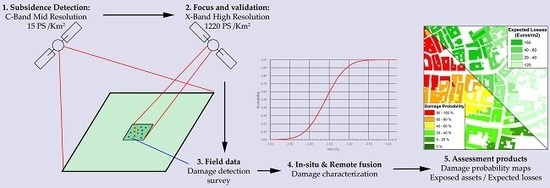
Abstract: The launch of the medium resolution Synthetic Aperture Radar (SAR) Sentinel-1 constellation in 2014 has allowed public and private organizations to introduce SAR interferometry (InSAR) products as a valuable option in their monitoring systems. The massive stacks of displacement data resulting from the processing of large C-B and radar images can be used to highlight temporal and spatial deformation anomalies, and their detailed analysis and postprocessing to generate operative products for final users. In this work, the wide-area mapping capability of Sentinel-1 was used in synergy with the COSMO-SkyMed high resolution SAR data to characterize ground subsidence affecting the urban fabric of the city of Pistoia (Tuscany Region, central Italy). Line of sight velocities were decomposed on vertical and E–W components, observing slight horizontal movements towards the center of the subsidence area. Vertical displacements and damage field surveys allowed for the calculation of the probability of damage depending on the displacement velocity by means of fragility curves. Finally, these data were translated to damage probability and potential loss maps. These products are useful for urban planning and geohazard management, focusing on the identification of the most hazardous areas on which to concentrate efforts and resources.
Sensors 2020, 20, 2749.
More Publications
-
 Analysing the Impact of Land Subsidence on the Flooding Risk: Evaluation Through InSAR and Modelling
A new paper entitled "Analysing the Impact of...
-

-

-
 A new Poster was presented in the Living Planet Symposium 2022
The RESERVOIR Project delegation (Gua...
-

RESERVOIR is part of the PRIMA Programme supported by the European Union. The PRIMA programme is supported under Horizon 2020 the European Union's Framework Programme for Research and Innovation. Grant Agreement number: [1924] [RESERVOIR] [Call 2019 Section 1 Water RIA]
#PRIMAProjects #Research #Innovation
@PRIMAInnovation @EuScienceInnov @EU_H2020

Copyright © RESERVOIR 2026. All rights reserved.