Spatial Analysis of Land Subsidence in the San Luis Potosi Valley Induced by Aquifer Overexploitation Using the Coherent Pixels Technique (CPT) and Sentinel-1 InSAR Observation
Navarro-Hernández, M.I.; Tomás, R.; Lopez-Sanchez, J.M.; Cárdenas-Tristán, A.; Mallorquí, J.J.
Abstract:
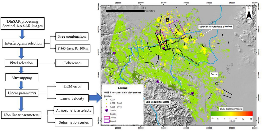
The San Luis Potosi metropolitan area has suffered considerable damage from land subsidence over the past decades, which has become visible since 1990. This paper seeks to evaluate the effects of groundwater withdrawal on land subsidence in the San Luis Potosi Valley and the development of surface faults due to the differential compaction of sediments. For this purpose, we applied the Coherent Pixels Technique (CPT), a Persistent Scatterer Interferometry (PSI) technique, using 112 Sentinel-1 acquisitions from October 2014 to November 2019 to estimate the deformation rate. The results revealed that the deformation areas in the municipality of Soledad de Graciano Sánchez mostly exhibit subsidence values between −1.5 and −3.5 cm/year; whereas in San Luis Potosi these values are between −1.8 and −4.2 cm/year. The PSI results were validated by five Global Navigation Satellite System (GNSS) benchmarks available, providing a data correlation between the results obtained with both techniques of 0.986. This validation suggests that interferometric derived deformations agree well with results obtained from GNSS data. The strong relationship between trace fault, land subsidence, and groundwater extraction suggests that groundwater withdrawal is resulting in subsidence induced faulting, which follows the pattern of structural faults buried by sediments.
Remote Sens. 2020, 12, 3822.
More Publications
-
 Analysing the Impact of Land Subsidence on the Flooding Risk: Evaluation Through InSAR and Modelling
A new paper entitled "Analysing the Impact of...
-

-

-
 A new Poster was presented in the Living Planet Symposium 2022
The RESERVOIR Project delegation (Gua...
-

RESERVOIR is part of the PRIMA Programme supported by the European Union. The PRIMA programme is supported under Horizon 2020 the European Union's Framework Programme for Research and Innovation. Grant Agreement number: [1924] [RESERVOIR] [Call 2019 Section 1 Water RIA]
#PRIMAProjects #Research #Innovation
@PRIMAInnovation @EuScienceInnov @EU_H2020

Copyright © RESERVOIR 2026. All rights reserved.